

Peddimore Travel Plan
Welcome to this interactive Travel Plan for Peddimore. This website will inform you of sustainable ways of travel to and from the site.
Scroll this menu to read more about travel options for walking, cycling, public transport, and driving more sustainably.
We have provided up-to-date travel information wherever possible. For more information on bus and rail services,
please click here.Look out for yellow highlighted text like this - it will indicate interactive features on the map.
Map Key
| Illustrative Site Boundary | |
| Future Langley Sustainable Urban Extension (SUE) | |
| Railway station | |
| Railway Line |
Walking and Cycling

Walking and cycling around Peddimore couldn't be easier.
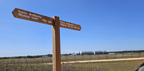
A network of footway and cycleways runs throughout the site along the
internal estate roads. A circular recreational route through the development's
landscaping can make a practical journey into something relaxing and enjoyable.
Click on the map markers to view active travel connections around the site, and to view key local amenities.
These Active Travel routes connect with the wider area's pedestrian and cycle network via:
- a traffic-free bridge across the A38 to link with Walmley Ash Lane (and the wider Langley SUE in future);
- connections to Wishaw Lane, Wiggins Hill Road and Cottage Lane.
Toggle the checkboxes below and zoom into the map to view approximate walking and cycling distances from Peddimore, to help you plan your journey.
Birmingham City Council are looking to implement Active Travel improvements in the area
during 2025. These have been developed with the help of a financial contribution by
IM Properties, and the routes can be viewed by toggling the checkboxes below.
These include pedestrian and cycle improvements:
- on Walmley Ash Lane;
- towards Sutton Coldfield, Wylde Green and Chester Road railway stations;
- on Cottage Lane to improve links to the canal;
- and a new toucan crossing to access the Minworth Retail Park.
Toggle the checkboxes below to view Birmingham City Council's proposed off-road and on-road Active Travel improvement routes in the area.
In future, there will be a new mobility hub in the north-west corner of the site. We will
provide staff and visitors with further information about this and any other site-wide active
travel facilities and schemes as they come forward.
Individual occupiers may also provide their own schemes for employees, such as Cycle to Work.
Check with your employer to find out what benefits may be available to you.
Map Key
| Illustrative Site Boundary | |
| Future Langley Sustainable Urban Extension (SUE) | |
| On-site Recreational Route | |
| On-site Pedestrian/Cycle Routes Adjacent to Highway | |
| Permissive Path | |
| Public Right of Way | |
| Birmingham & Fazeley Canal Towpath | |
| Local Amenities | |
| Active Travel Connections | |
| Railway station | |
| Railway Line | |
| National Cycle Network | |
| Regional Cycle Network | |
| Local Cycle Network |
Public Transport

Public transport is an attractive way to travel to and from Peddimore,
as shown by a recent travel survey where 28% of employees responded to
say they travelled by bus.
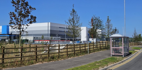
There are several bus stops on site, each located so that every building will
be within a 400 metre walk of the Peddimore bus services. Each of the outbound
bus stops includes shelters with seating and real-time timetable information.
Both the 64/x64 and 68 bus services enter Peddimore via the A38. In future, as
the Langley SUE is developed, buses will be able to travel across the A38 to
access bus stops within it.
The map shows the nearest bus stops to Peddimore. Click on the bus stops to see which services they provide.
You can find bus journey planner tools
by clicking here.
There are several more bus stops within a short walking distance of Peddimore.
These are located on Lindridge Drive, to the east of the Minworth Island which
provides access to the 77a bus service (Erdington - Sutton Coldfield - Walsall).
The 71 and 76 bus services are also available from bus stops a short distance
south of here on the A4097 Kingsbury Road arms of the Minworth Island.
Initial trials with the 71 bus service indicated that current demand is insufficient
to support a direct bus route between Peddimore and Sutton Coldfield. Nevertheless,
this demand will be reassessed as the development progresses. In addition, the new
Cross-City Package 4 bus route will connect Longbridge to Sutton Coldfield town centre
via Peddimore and Langley once implemented.

Transport for West Midlands (TfWM) runs the Workwise travel scheme. This offers eligible newly
employed people two 4-week travel passes free and the third at half price.
To check if you are eligible for the scheme, or to find out more about Workwise, visit
Map Key
| Illustrative Site Boundary | |
| Future Langley Sustainable Urban Extension (SUE) | |
| On-site Recreational Route | |
| On-site Pedestrian/Cycle Routes Adjacent to Highway | |
| Permissive Path | |
| Public Right of Way | |
| Birmingham & Fazeley Canal Towpath | |
| Bus stop | |
| x15 Bus Service Birmingham - Sutton Coldfield | |
| 64/x64 Bus Service Birmingham - Peddimore | |
| 67 Bus Service Birmingham - Castle Vale | |
| 68 Bus Service Birmingham - Peddimore | |
| 71 Bus Service Chelmsley Wood - Sutton Coldfield | |
| 76 Bus Service Tamworth - Sutton Coldfield | |
| 77 Bus Service Walsall - Erdington | |
| 77A Bus Service Walsall - Erdington | |
| 96 Bus Service Chelmsley Wood - Kingstanding | |
| Railway station | |
| Railway Line |
Driving More Sustainably

A key way to reduce car journeys to and from the site is to encourage car sharing.
Often the driver is the only person in the car, and we can make journeys more
sustainable by carrying passengers who would otherwise drive their own vehicles.
A recent travel survey shows car sharing is a popular way to travel to and from Peddimore,
with an average of 43% of those employees driving a car to work also carrying a passenger.
This is encouraged by a car share scheme to help employees match with someone to share a
car with. If you participate in this car share scheme, you will have dedicated parking within
the development. For more details of the car share scheme, get in touch with your employer,
who will be able to give you more information.
Click on the map markers for more information about car parking facilities available on site.
As more people switch to electric vehicles, it is becoming more important to provide the
infrastructure that enables this. Occupiers will provide charging points on site, which will
help enable their staff and visitors to make the switch to a more sustainable vehicle.
In addition to cars, the provision of secure motorcycle parking and CCTV will give you the
security of mind that your bike will be safe if you drive it to the site. If more
bikes are used to commute to Peddimore, congestion on the roads nearby will reduce.
As site occupation grows, provision will be made for facilities that make access to the
site easier and more sustainable, such as car club parking spaces, and electric bike / electric
scooter provision. We will provide more information about these facilities and schemes as they
come forward.
Map Key
| Illustrative Site Boundary | |
| Future Langley Sustainable Urban Extension (SUE) | |
| On-site car parking facilities | |
| Railway station | |
| Railway Line |
Thank you for reading

Thank you for taking the time to read the information on this website, and for
considering how you could travel more sustainably to and from Peddimore.
We hope this information is useful and you feel encouraged to plan your journeys to
Peddimore to make the most of pedestrian and cycle links, public transport, and
by driving more sustainably.
question_answer Give feedback here
Click on the yellow button above to provide any feedback you have on your journeys
to Peddimore, or to report any issues you have experienced with your travel. We
would also like to hear if you have any feedback relating to this website.
If you have any further questions about active and sustainable travel to and from Peddimore,
please contact our Travel Plan Coordinator by emailing
The information on this website will be kept up to date where possible, and you are invited to refer back to it in future when planning your journeys.
Map Key
| Illustrative Site Boundary | |
| Future Langley Sustainable Urban Extension (SUE) | |
| Railway station | |
| Railway Line |
Brought to you by:

We have achieved Green level Modeshift STARS accreditation.
An
Engaged Space community engagement on behalf of IM Properties.
Powered by
Deetu.
Got a story to tell?
Get in touch.

touch_app Back to the start
